Drought and smoke in a tourist paradise
The disappearance of waterways in western Pará upends fishing and tourism, the pillars of the local economy.
Part of the series:
CLIMATE CHANGE IN THE AMAZON
Photo/text: Vinicius Sassine and Lalo de Almeida
SANTARÉM, DECEMBER 2024: Walking through a dried stream or lake is unsettling. There is silence and a complete absence of life absence of life; a dystopian scene.
In regions of the lower Tapajós River and the Amazon River floodplain near Santarém (PA), an extreme, prolonged drought imposes the unsettling sensation on hundreds of families. For months on end, these people find themselves in spaces transformed in a way never before experienced.
About the series:
In the fall of 2024, Rainforest Foundation Norway sent investigative journalist Vinicius Sassine and award-winning photographer Lalo de Almeida to document the human and environmental costs of climate change in the Amazon Rainforest.
The stories were originally published by Brazil's largest broadsheet newspaper, Folha de São Paulo.
At the end of September, ANA (National Water and Basic Sanitation Agency) declared a water emergency for the lower Tapajós in western Pará to draw attention to the river's critical state and encourage measures to mitigate the unprecedented low.
Since then, the Tapajós and Amazonas rivers —which meet at Santarém—have dropped even further, directly affecting communities located along the banks of the rivers, streams, and lakes.
Dry bed of Pacoval Lake in the Igarapé do Costa community, in the floodplain area of the Amazon River, near Santarém (PA) - Lalo de Almeida/Folhapress.
Although the sheer volume of water in the river remains high, due to their Amazonian proportions, their fringes have shrunk unprecedentedly, resulting in the death of streams and lakes fed by the main waterways.
As a result, the Indigenous Quilombolas people and river communities find themselves forced to adapt to a radically altered landscape. The presence of traditional communities in this part of the Amazon is directly linked to bodies of water that have now dried up.

Children observe a stagnant water puddle in the Mapiri stream bed, in the Mapirizinho village, located on one of the banks of the Tapajós River - Lalo de Almeida/Folhapress.
The Kumaruaras of the Mapirizinho village originally settled there—landward from the Tapajós River shore, in the Tapajós-Arapiuns Extractive Reserve—because of Mapiri, a stream that disappeared during the extreme drought of 2024.
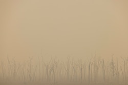
On the other side of the river, Alter do Chão, a well-known Amazonian tourist paradise, remains shrouded in smoke from fires.
According to the oral history of Saracura’s Quilombolas, located in an Amazon River floodplain area, the community’s existence began with a healer arriving in a coastal area beside the Piranhas Lake. Fleeing enslaved people followed, according to the Quilombola descendants.
In 2024, both the vast lake preceding the community and the stream dried up, followed by an alarming fish die-off.

Quilombola from Saracura community walks through the dry bed of Piranhas Creek, in the Amazon River floodplain - Lalo de Almeida/Folhapress
About the Tapajós-Arapiuns Extractive Reserve
- Established in 1998
- Area of 677,500 hectares, encompassing 72 communities
- Indigenous people of different ethnicities, such as Kumaruara, Tupinambá, and Munduruku, in 54 communities
- Houses 27,000 residents, divided amongst 4,500 families in 3,500 homes
- Communities are distributed along the margins of the Tapajós, Arapiuns, Maró, and Inambú rivers, engaging in agroextractive activities, farming, and fishing
Sources: ICMBio Diagnosis of 2014 and Indigenous Council of the Kumaruaras Territory
The transformations are radical, demanding changes in people’s lifestyles regarding basic needs—like obtaining potable water in a place ironically home to some of the most voluminous rivers on earth—and finding new ways to subsist and travel.
The houses in Mapirizinho village were built closer to Mapiri stream than the Tapajós River. Due to the severe drought and formation of immense sandbanks in the river, distances have increased. Motorcycles are now used for transport after boat trips along Tapajós.

Sand beaches formed in the Tapajós River at the entrance to Mapirizinho village due to extreme drought - Lalo de Almeida/Folhapress
In Saracura, the Quilombolas had never used ox carts, but the drought caused such deep isolation that transporting food became impossible without support. The community built ox carts, training animals for the task. The first was made in 2023, another year of severe drought. By 2024, six vehicles are in use.
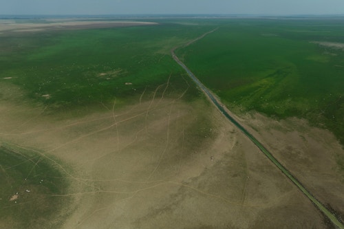
For the movement of Igarapé do Costa’s river communities, now without Pacoval Lake, Santarém's City Hall provided a pickup truck to the community. The boats anchor at the shore, and the rest of the path—where there was once water—is made by car. From the shore to the community is a 12 km journey within the truck, traversing the now nonexistent lake.
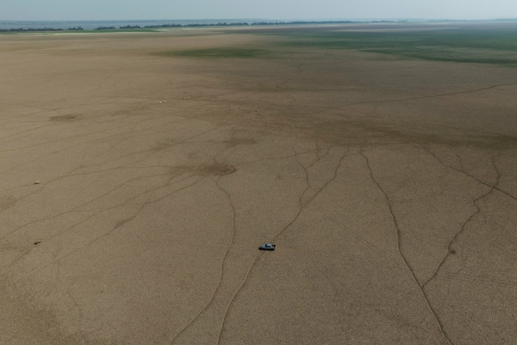
Santarém City Hall's truck used to travel kilometers through the dried lake in the Igarapé do Costa community - Lalo de Almeida/Folhapress
The Kumaruaras' stream, Saracura's Quilombola lake, and the lake of Igarapé do Costa's river communities will return with the flooding season. But the Amazon's natural cycles are severely disrupted.
There have already been two severe and prolonged droughts with worsening effects. River communities expect less lively waterways—with far fewer fish.
“What remains of the stream are stagnant pools," says Roselino Paz Kumaruara, 49, chief of Mapirizinho. "This community emerged long ago because the ancients searched for water and found Mapiri stream. This year it vanished."

Roselino Kumaruara, chief of Mapirizinho village, observes the dry bed of Mapiri stream, essential to the community's origin - Lalo de Almeida/Folhapress.
With the drought, the village's 42 families rely on a well and a water distribution system designed for two communities. Consuming water from holes dug near the stream proved disastrous for residents; many fell ill, suffering diarrhea, vomiting, and headaches. This water from the holes is still used for bathing.

A well was dug next to the dry bed of Mapiri stream, known as a cacimba - Lalo de Almeida/Folhapress.
Villages and other Tapajós-Arapiuns Extractive Reserve communities face similar realities. “We thought it might be just the El Niño effect, but the drought returned in 2024. What about the years ahead?” questions Ana Livia Kumaruara, 28, part of the Indigenous council’s coordination in the reserve.
The extreme drought in the Brazilian Amazon, both west and east, is a confluence of factors: El Niño's incidence (above-average warming in the Pacific Ocean near the equator) in 2023 and part of 2024, Northern Tropical Atlantic warming, deforestation, forest degradation—linked to fires—and climate change.
Measurements from the Pará Environment Secretariat show how much the river has declined over the drought:

Measured in meters, the depth of the Tapajós river, Santarém state, in 2024. Source: Hydrometeorological Monitoring Unit, Pará Environment Secretariat.
The drought prolongs, often starting earlier - as occurred this year - over much of the biome. Rivers struggle to return to normal at the start of the flood, triggering a new extreme drought period.
The stream and Piranhas Lake, subsistence sources in the Quilombola community where about 90% of the 164 families rely on fishing, have been entirely dry for a month and a half.
The grass grows, and the cattle take over. Around 2,000 cattle graze where there once was water and fish. Water barrels are brought from Santarém for residents’ consumption.

Franciney de Jesus, Quilombola leader, attempts to walk on the almost vanished lake shore due to extreme drought - Lalo de Almeida/Folhapress
Nothing survived in the remaining pools.
“In the flood, fish come near homes. Curimatá, surubim, pirarucu, all types swam in this lake,” states Franciney Oliveira de Jesus, 42, a Saracura leader, while walking through former water grounds. “With these kills in the floods now, there will be fewer fish."
Igarapé do Costa is near Saracura, in the same Amazon floodplain area. What occurred in the river community is incomparable.
Tonnes of fish of different species, including pirarucu, the symbol of sustainable Amazon management, died in leftover stream and channel trickles.
Seven communities, with 500 families, depended on these spaces for subsistence. The environmental disaster unprecedentedly affected fishermen’s routines.

Tonnes of dead fish in Igarapé do Costa stream, in the Amazon floodplain - Lalo de Almeida/Folhapress
Dead fish and other animals, such as caimans, turtles, and stingrays, covered water surfaces. River communities had to drag the organic matter to the shore for burning.
In elevated temperature and oxygen-deprived water, various fish species struggled for life, seeking surface oxygen. Around a hundred turtles, agonizing, were moved by fishermen to a clean water well, resistant to heat and drought.

River communities move a turtle to a clean water well in Igarapé do Costa amid fish kill - Lalo de Almeida/Folhapress.
Now, no one dares to imagine the future.
“Our concern is when the water arrives. The current time is spawning season. All fish died; how will they spawn?” questions Erick Penna Ribeiro, 33, president of the Costa Stream residents association. “From March onward, when the fishing ban ends [the annual period when fishing is prohibited for reproduction], there will be no fish."
The council president covering seven affected communities, Ednei José da Gama, 49, offers a similar outlook. “Don’t expect much from the canal. Surubim, pescada, almost all died,” he says.

Aerial view of Igarapé do Costa, where there was unprecedented fish kill in the Amazon floodplain - Lalo de Almeida/Folhapress.
Fishermen received emergency assistance from the federal government—two minimum wages—to manage the drought’s emergency, according to river community accounts. The MMA (Ministry of Environment and Climate Change) stated that water samples would be collected for analysis. Teams from Santarém and Pará government Environment Secretariats visited the community for data collection.

Fishermen unload newly caught pirarucus in a race against time amid oxygen scarcity in the water - Lalo de Almeida/Folhapress.
The climate emergency in western Pará is most visible in Santarém and Alter do Chão, a district home to 332,000 residents.
Santarém spent days shrouded in dense smoke, with air quality at dangerous levels due to uncontrollable forest area fires. The smoke also covered Alter do Chão, internationally renowned for its fine sand beaches and crystal waters.

Aerial view of Ilha do Amor in Alter do Chão, district of Santarém, a popular tourist destination. With extreme drought, it's possible to walk to the peninsula. - Lalo de Almeida/Folhapress.
The drought changed the landscapes of tourist spots. Remote beaches with hotel and restaurant infrastructure became unable to welcome visitors. River sections dried, and the water became mud-like. Lagoons and animal observation channels transformed into sludge. Industry guides report a 28% drop in tourist numbers.
On the other side of paradise, extreme drought alters life for those accustomed to invisibility. With the death of lakes and streams at the communities’ formation roots, nobody is certain about future Amazon cycles.

Muddy feet of Franciney de Jesus, Quilombola leader, after walking through the dry lake bed in Saracura community - Lalo de Almeida/Folhapress.